|
Monitoring Details
Monitoring: A Question of Priority
Consider the scenario that you have been hired by
the Bureau of Land Management to manage 20,000 acres that
include forests and rangelands intersected by riparian areas. Within these
areas you have an endangered species
of owl and 3 fish species of concern.
You may also have considerable fire fuel
build-up or areas where soil erosion is making
slopes unstable above
roads and streams. In summary, you have many management goals
and concerns. If you are asked to produce a monitoring protocol you first
need to set your management priorities.
Thankfully, several organizations have produced guidelines on how
to go about defining the priority of one species or
management objective over
another.
Monitoring: Established Priority Systems
An
example of a ranking system is one developed to rank the
abundance of rarity of species created by the
Natural Heritage Program. The main levels of this system are:
-
Critically Imperiled
-
Imperiled
-
Very Rare and Local
-
Apparently Secure
-
Demonstrably Secure
-
Status Uncertain
In this system, the first 3 priority levels are defined by the
number of individuals. For example, critically imperiled refers
to < 5 occurrences or <1000 individuals; whereas imperiled
refers to 6-20 occurrences and <3000 individuals.
The level "Status Uncertain" refers to instances
where not enough information about that species exists to determine whether the species is at risk.
Inventory methods could be used to assess the
current status of a species. Monitoring protocols could be
subsequently applied to evaluate whether the populations of those species are
increasing or declining.
An example of how matrices could be use to
include several biological and management criteria to rank
importance of monitoring among species and situations is
presented on
page 32 and 33 in
Measuring and Monitoring Plant Communities. In this
example, the following biological and management criteria have
been included:
BIOLOGICAL CRITERIA:
• rarity
• taxonomic status
• sensitivity
• known decline
• extent of threats
• immediacy of threats
MANAGEMENT CRITERIA:
• existing conflict
• monitoring difficulty
• availability of
management actions
• recovery potential
• public interest
• potential for crisis
Monitoring: Establish Your Own Priorities
There are many cases where a defined priority
system does not exist for a specific monitoring task and you will
need to set your own priorities. The bottom line in selecting
monitoring sites and activities is that they be POSSIBLE and
will give USEFUL information.
Here are few points that
should be considered when initiating monitoring activities:
-
Are important legal or policy considerations driving monitoring
such as sensitive or endangered species that occur in the area?
-
Are there management activities pending for which it will be
necessary to evaluate impact or effectiveness?
-
Are there growing changes in land use activities, such as
recreation, that might cause changes to the plant community.
-
Are management decisions being made, such as a grazing permit
renewal, for which monitoring information would be valuable to monitor
outcomes?
-
Is there growing public interest in a specific area, activity,
or species for which monitoring data might be valuable to inform or resolve
potential conflicts?
-
Can areas be identified for which management activities will be
able to cause changes it the plant community?
-
What human, agency, or financial obstacles exist to monitoring
activities?
Monitoring: Scale and Complexity
There is rarely, if ever, enough time or money to
conduct necessary monitoring activities. The extent to which you conduct
monitoring will be limited in both space and time. As such, it is important before starting any monitoring
protocol to know what your scale of
assessment is going to be. Clearly this will depend on
many factors beyond purely your available resources. For
example, monitoring the annual forage range of sheep may require
a larger spatial extent for measurements than if you were
interested in the feeding habitat of a meadow vole.
Scale can
be simply defined as the spatial extent of your monitoring program. Clearly, the
scale at which your measurements are taken should correspond to your management
objectives and include the spatial extent that the features your are measuring. The scale at which you are making measurements should always be explicitly defined.
In a similar way, the level of complexity in
your measurements and the level or replication will vary depending on your
specific management objectives.
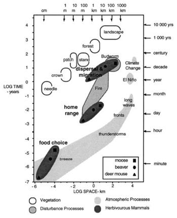
Image Source: Peterson, G., C. R. Allen, C. S. Holling. (1998). Ecosystem
Resilience, Biodiversity, and Scale. Ecosystems 1: 6-18.
* The word scale
has many meanings depending on your application. Example include: (1)
cartographic scale: the ratio of true distance in the field to distance on a
map; (2) Landscape ecology: the bracket of space (and/or time) that you would
expect to observe an object or process; in addition to of course geological or
anatomical features! |