| Mangrove Forest Research in
Mengkabong, Sabah, Malaysia
|
|||||||||||||||||||||||||||||||||||||||||||||||||||||||||||||||||||||||||||||||
By Sarva Mangala Praveena, Miroslav Radojevic, and Mohd Harun Abdullah |
May 2008 | ||||||||||||||||||||||||||||||||||||||||||||||||||||||||||||||||||||||||||||||
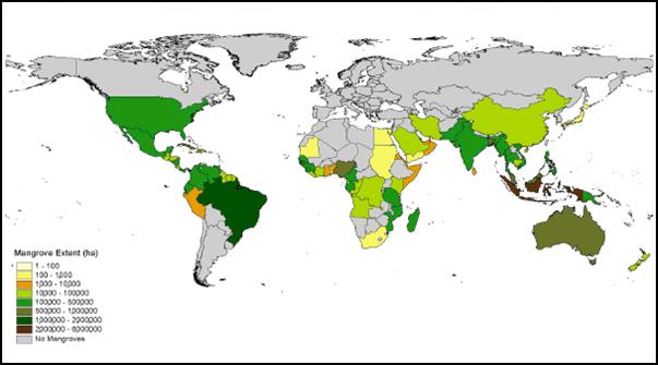
INTRODUCTION Mangroves are marine tidal and estuarine forests that cover the globe’s surface in subtropical and tropical regions (Ramsar Convention, 2004). In the World Mangrove Atlas (1997), Spalding et al. reported that the world mangrove area is over 18 million ha, while research done by Aizpuru and others (2000) estimated the total global area of mangroves in 112 countries in the world to be just over 17 million ha (Figure 1). On a global scale, the mangrove forests stretch from the northern-most part of the worlds tropical forests to its southern regions. This forest type stretches from northern Florida in the U.S.A. down to the Argentina coast in South and Central America. Mangrove forests are dotted along both coasts of Africa and spread across to the Indian sub-continent and all the way up to Ryukyu (Okinawa) in Japan. Further to the south, this forest type reaches down to Australia and New Zealand, and is found throughout the Indo-Malay area. The world’s mangrove forests are only found in areas of warm oceanic currents (Jahara Yahya and Santha, 2003; Ramsar Convention, 2004). Figure 1. Worldwide distribution of mangroves (Forestry Dept., FAO, United Nations, 1994).
About 70 countries have mangrove areas that include 79 mangrove species. The entire geographic extent of this forest type has yet to be completely studied and mapped, especially on small islands in the Southern Pacific and the Lesser Antilles. However, eight countries have over 50% of the mangroves of the world (Table 1). Table 2 shows changes in regional mangrove areas from 1980-2000. Table 3 estimates the mangrove areas in several countries (km2). The most extensive area of mangroves is found in Asia, followed by Africa and South America. Table 2 shows that mangroves areas are declining year by year. Total area covered by mangroves decreased by 21.07% from 1980 to 1997 and an alarming 11.66% from 1997 to 2000.
Table 1. Estimation of mangrove areas in major mangrove-holding countries (Jahara, Yahya, and Santha, 2003).
Table 2. Mangrove status by regions.
aForestry Dept., FAO, United Nations (1994). bSpalding et al. (1997).
Table 3. Estimates of mangrove areas (km2) in major mangrove holding countries, by region (Aizpuru et al. 2000).
The tropical coastal zone is one of the most biogeochemically active regions of the biosphere. It represents an important sink and source of carbon (Saenger and Snedaker, 1993). Mangrove forests are dominant ecosystems along tropical coastlines and are important interfaces in the exchange of sediment, organic materials, and gases between land, atmosphere, and ocean (Aksornkoae, 1993). These woody plants grow at the interface between land and sea in tropical and sub-tropical latitudes, and they exist in conditions of high salinity, extreme tides, strong winds, high temperatures, and muddy, anaerobic soils. There may be no other group of plants with such highly developed morphological and physiological adaptations to extreme conditions (Kathiresan and Bingham, 2001). Through their productivity, mangroves contribute significantly to coastal ecosystems and play a vital role in coastal protection and fisheries production by soaking up nutrients (Eong, 1993). Marchand et al. (2004) described mangrove ecosystems as often being reactive to differences in soil salinity, pH, frequency of tidal inundation, sedimentation, soil chemistry, freshwater inputs, and groundwater availability. Ha et al. (2003) noted that these factors are thought to have lead to the great variation found in mangrove community structure and function, even within small geographic ranges (mangroves only a few kilometers apart may be strikingly different in character). Forty species of mangroves dominate approximately 75% of the world's tropical coastlines between 25° N and 25° S. In certain locations, this range extends beyond these limits due to the movement of unusually warm waters from the equator. Such areas include the coasts of East Asia, Africa, Australia, and the Americas where mangroves occur 10-15° farther south. Mangroves in the Indo-West Pacific are more diverse than those in East Asia, Africa, Australia, and America, and have an exceptionally high species diversity consisting of more than 30 tree species (Environmental Protection Agency, 2006).
UNIQUENESS OF MANGROVE FOREST Mangrove forests are among the world’s most productive, prominent, and complex ecosystems dominated by salt-tolerant trees and shrubs (Giesen and King, 1997). The rate of primary productivity is high in these forests (Bosire et al., 2005; Buoilllon et al., 2003), producing organic carbon in excess of the ecosystem requirements and contributing significantly to the global carbon cycle (Kathiresan and Bingham, 2001; Eong, 1993; Bouillon et al., 2003). Mangroves grow at the interface between land and sea in dynamic chemical and physical conditions. These intertidal ecosystems are found along many coastlines in the tropics and subtropics, but the most highly developed mangrove forests are found in sheltered bays, estuaries, and lagoons on sediments that are flooded by daily tides and currents (Giesen and King, 1997). Mangrove forests are an important transition zone found in the inter-tidal zone of tropical and subtropical region. This forest plays an important role in protecting the bank against tide, removing pollutants, enhancing nutrient cycling, as well as providing vital habitats and feeding sites for aquatic organisms (Jingchun et al., 2006; Ramanathan et al.,1999; Shriadah, 1999). Sediment can be a sensitive indicator for both spatial and temporal trends in marine environment. Despite the importance of mangroves, they are being destroyed at an alarming rate and it has become a matter of some urgency to understand trophic interactions and material flow within these ecosystems. Mangroves and mangrove ecosystems have been studied extensively but remain poorly understood and despite such studies, mangrove habitats continue to shrink around the world. With continuing degradation and destruction of mangroves, there is a critical need to understand them better (Kathiresan and Bingham, 2001).
THE NEED FOR SUSTAINABLE MANGROVE FOREST MANAGEMENT Traditionally, mangroves have been seen as waste lands and, where possible, have been converted for urban development, irrigated agriculture and, more recently, aquaculture. However, there is a growing realization of their importance as natural habitats, and an understanding that better water management does not necessarily translate to drainage or greater control of water within the forests. Recognizing the values and functions of wetlands such as mangrove forests presents a direct challenge to the traditional objectives of water management and raises the need for re-definition of water management goals. Better water management is frequently taken to mean integrated water management, without any serious attempt to understand what will result. Often it represents an attempt by a minority interest to capture or increase a share of benefits from water management for itself. In reality, better water management should represent an attempt to address the interactions across the interfaces of the biophysical and socio-economic systems, in order to achieve a sustainable outcome. It must, by definition, address the needs and interests of all stakeholders in the system (Franks and Falconer, 1999). Research in progress in Malaysia and India is investigating some of the issues surrounding integrated water management in wetlands such as mangrove forests. The broad aims of these research projects in Malaysia and India include improvement in the modeling of the complex hydrodynamics of mangrove estuaries; increased understanding of the cycle of nutrients, particularly carbon, nitrogen and biomass, in different components of mangrove systems; and to incorporate these improvements in models for more accurate predictions, and to apply the models as tools in planning and management for the long-term sustainable use of mangrove systems as natural resources (Franks and Falconer, 1999).
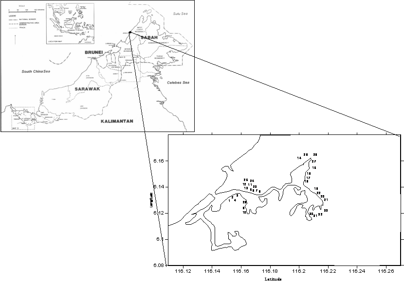
RESEARCH CONDUCTED We conducted research on mangrove forest in Mengkabong, Sabah, Malaysia. This study took place in Tuaran District, on the west coast of Sabah. The area includes Mengkabong Bay, 40 km from Kota Kinabalu. The total study area ranges from latitude 06006’N–06011’N and longitude 116008’E–1160 13’E (Figure 2). Figure 2. Location of Mengkabong Bay and mangrove surface sediment sampling sites.
The Mengkabong mangrove forest consists of two shallow spurs, with the southern spur forming the administrative boundary between Tuaran and Kota Kinabalu Districts. This spur ends in Salut Bay, which is entirely surrounded by an industrial zone, the Kota Kinabalu Industrial Park (KKIP). The southern spur of the estuary has been significantly degraded already and there is little left to protect. The northern spur is much larger and more irregular. There are still abundant and high quality mangroves remaining around the estuary (Environmental Impact Assessment, 1992; Town and Regional Planning Department of Sabah, 2003). The Mengkabong mangroves, Tuaran District, experienced a 15% decrease from 1991 to 2000. In 1991, the mangroves covered 12.6 km2 but decreased to 10.7 km2 in 2000. Most of the mangroves have been lost due to the spread of rural development such as housing and aquaculture projects, and through impacts of being surrounded by the KKIP industrial zone (Environmental Indicator Report, 2003). A study of Mengkabong lagoon mangrove sediment was conducted. The sampling strategy was to study the spatial variability and tidal effects on a number of parameters. Mangrove surface sediments were chosen for this study because this layer controls the exchange of metals between sediments and water (El Nemr et al., 2006). Mangrove sediments were sampled randomly and taken in triplicates with an auger at 33 stations at low and high tide from March 2006 to November 2006 (Figure 1). We investigated the following parameters: pH, electrical conductivity, salinity, organic matter, base cations (Na, K, Ca and Mg), and heavy metals (Fe, Cu, Pb, Zn and Al). Our results showed that the associations between the parameters mainly related to anthropogenic inputs and reflect the complexing nature of clay. Furthermore, the relationships between organic matter, graunometric fractions, heavy metals, and base cations are a function of ionic strength of sediment and surface complexation. The applications of various indices (Enrichment Factor, Index of Geoaccumulation, Pollution Index, and Marine Sediment Pollution Index) were used to demonstrate the current quality status of mangrove sediments at our study site. Sediment quality guidelines applications used by agencies around the world (including the Washington Department of Ecology, Australian and New Zealand Environment and Conservation Council (ANZECC), and Swedish Environmental Sediment Quality) were applied to the Mengkabong lagoon mangrove sediment data. We found that the most appropriate index and guideline were the Marine Sediment Pollution Index and the Interim Sediment Quality Values for Hong Kong (ISQV-low and ISQV-high). Comparison with these indices and guidelines showed that all the metals at our site were in Class A, confirming that it was in low contamination condition and below the ISQV-low threshold.
FUTURE RESEARCH Future mangrove studies should focus on biological, ecological, and chemical aspects and impacts of mangrove forest management. It is crucial to establish baseline data for management: for both preservation and comparison with other studies elsewhere. There is also a great need to investigate the chemistry of mangrove sediments: in particular, the identification of the factors that contribute to acidification and understanding the geochemical modifications in mangrove soil are of interest. Future research should also include site-specific ecological analysis of exisiting benthic community structure (crabs, molluscs, mudskippers, and other species), and focus on understanding the impact of sediment contamination on this community. Organic compounds (pesticides, PAHs, and PCBs) should be intergrated into contamination evaluation and correlated with other parameters. Finally, mangrove hydrology should be a focus of future research. Research has been published on mangrove hydrology under tidal inundation, freshwater flow within the mangrove forests, topography, mangrove species, and the physical and chemical characteristics of mangrove forests. There is less understanding of the role these factors play in mangrove geochemistry, and as mangrove forests undergo modification. It is vital to obtain this type of information regarding mangrove hydrology in order to establish mangrove restoration programs. In the case of Mengkabong lagoon, this information is needed for thoughtful decision-making and effective and appropriate mangrove resources management.
REFERENCES Aizpuru, M., Achard, F. and Blasco, F. 2000. Global Assessment of Cover Change of the Mangrove Forest Using Satellite Imagery at Medium To High Resolution. EEC Res. Proj. 15017-1999-05 FIED ISP FR, Joint Research Center, Ispra. Bosire, J.O., Dahdouh-Guebas, F., Kairo, J.G. and Koedam, N. 2003. Colonization Of Non-Planted Mangrove Species Into Restored Mangrove Stands In Gazi Bay, Kenya. Aquatic Botany 76: 267-279. Bouillon, S., Frankignoulle, M., Dehairs, F., Velimirov, B., Eiler, A., Abril, S. G., Etcheber, H. & Borges, A. V. 2003. Inorganic and Organic Carbon Biogeochemistry in The Gautami Godavari Estuary (Andhra Pradesh, India) During Pre-Monsoon: The Local Impact of Extensive Mangrove Forests. Global Biogeochemical Cycles 17: 1114-1121. El Nemr, A., A. Khaled and Sikaily A. E. 2006. Distribution and statistical analysis of leachable and total heavy metals in the sediments of the Suez Gulf. Environmental Monitoring and Assessment 118: 89-112. Environmental Protection Agency, 2006. WETLANDS. http://www.epa.gov/owow/wetlands. 23 March 2006. Forestry Department of Food and Agriculture Organization of the United Nations, 1994. Office of the United Nations High Commissioner for Human Rights. Geneva, Switzerland. Franks, T. and Falconer, R. A. 1999. Developing Procedures for the Sustainable Use of Mangrove Systems. Agricultural Water Management 40: 59-64. Giesen, W. and King, K. 1997. Incremental Costs of Wetland Conservation: Case Studies in Asia and the Pacific. Kuala Lumpur: Wetlands International. Ha, H. T., Duarte, C. M., Tri, N. H., Terrados, J. H. and Borum, J. 2003. Growth and Population Dynamics during Early Stages of the Mangrove Kandelia Candel in Halong Bay, North Vietnam. Estuarine, Coastal and Shelf Science 58: 435–444. Kathiresan, K. and Bingham, B. L. 2001. Biology of Mangroves and Mangrove Ecosystem. Advance Marine Biology 40: 81-251. Ramanathan, A. L., Subramaniam, V., Ramesh, R., Chidambaram, S. and James, A. 1999. Environmental Geochemistry of the Pichavaram Mangrove Ecosystem (Tropical), Southeast Coast of India. Environmental Geology 37: 223-233. Shriadah, M. M. A. 1999. Heavy Metals in Mangrove Sediments of the United Arab Emirates Shoreline (Arabian Gulf). Water, Air and Soil Pollution 116: 523-534. Spalding, M.D., Blasco, F. and Field, C.D. (eds.) 1997. World Mangrove Atlas. The International Society for Mangrove Ecosystems, Okinawa, Japan. Town and Tegiona Planning Department, 2003. Environmental Local Planning. 3rd Floor, Block B, Wisma Tun Fuad Stephens, Kramunsing 88646 Kota Kinabalu, Sabah.
Sarva Mangala Praveena received her B.Sc. with Honors in 2005 and M.Sc. degree in 2007, both in Environmental Science from the Universiti Malaysia Sabah, Kota Kinabalu, Sabah, Malaysia. She is currently a postgraduate student at School of Science and Technology, Universiti Malaysia Sabah, majoring in environment and soil chemistry. Miroslav Radojevic is an Associate Professor in Environmental Science with the Faculty of Engineering and Computer Science, The University of Nottingham, Malaysia Campus. His research interests are mainly in air and haze pollution, soil and water analysis, and environmental pollution. Mohd Harun Abdullah is Professor of Environmental Science at the School of Science and Technology, Universiti Malaysia Sabah. His current interests are mainly in small islands groundwater chemistry and pollution, water chemistry, and soil and sediment pollution. The authors’ mailing address is: School Science and Technology, Universiti Malaysia Sabah, Locked Bag No. 2073,88999 Kota Kinabalu, Sabah, MALAYSIA. Corresponding author Sarva Mangala Praveena can be reached by email at smpraveena@gmail.com.
|
|||||||||||||||||||||||||||||||||||||||||||||||||||||||||||||||||||||||||||||||