|
Working in the “High Country” of New South Wales, in
Kosciuszko National Park, Australia
|
|
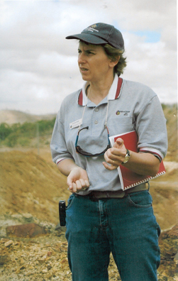
By Corinne Unger |
January 2006 |
Sheep and cattle grazed the high country of New South Wales, Australia for 135 years in what is now a national park. Introduced to the area as early as the 1820s, grazing animals were progressively excluded over a period of time as legislative changes were applied and the “Kosciuszko State Park" was declared in 1944, (becoming a national park in 1967). The last grazing leases ended in 1972. The impacts of more than a century of grazing and associated burning practices changed the vegetation and the alpine landscape. Especially tasty species, such as alpine celery, were almost completely removed by selective grazing. Fires were deliberately lit by graziers to encourage fresh green growth of grasses to feed their animals. Fires also left soils exposed and vulnerable to frost heave and once lifted and softened, the soils would quickly wash away with the next rain or melted snow. Snow patches became deep bare hollows which expanded each year. Once grazing ceased, erosion control works were undertaken by the NSW Soil Conservation Service in the 1960s and 1970s. I worked for the NSW Soil Conservation Service, first in Goulburn and then in Cooma, from 1983-87. My boss, John, had been involved in the planning and construction of works in the national park area in the 1970s. After the erosion control works were implemented, an extensive monitoring period followed, focussed on assessing how these areas were recovering. When I was transferred to Cooma, NSW to work with John, I was able to learn about this work from him as well as being able to plan and supervise other revegetation and stabilization works in the National Park each summer. Each January we trekked to the monitoring plots to assess the revegetation. This was part of my job as “Soil Conservationist – Mountains.” We had to wait until most of the snow had melted each spring to gain access to the sites to monitor the vegetation plots. John and I would choose a week in January to do this work. We would get ready early in the day, then drive to where the road ends at Charlotte’s Pass, and walk to the monitoring sites. Each stage of the journey took us higher up the mountains. We would take everything we needed for the day on our backs and in jacket pockets - food, drink, pens, notebooks, camera, additional wet weather gear, and radio. Initially our walk headed downhill through the scattered olive green and dark brown trunks of the black sallee woodland (a sub-alpine eucalyptus species), to the Snowy River where we waded across in knee-deep, icy clear water. After a few steps our feet were numb from the cold, stubbing toes on the rounded granite cobbles in the river—what a relief to put boots back on when we got to the other side! It was all uphill after that to the Main Range. After a short distance we’d trekked above the 1800m treeline, the black sallees were behind us and then it was alpine grasses, low heathy shrubs and groundcover species. Thin cold thin air challenged my fitness. My boss, a smoker, muttered to himself often, about giving up the cigarettes, particularly on the uphill climbs. As we approached the vegetation plots we left the main track and walked over hummocky soft snow grasses and around bogs to reach the ridge. It was heavy going—like walking in soft sand. I found myself looking at the ground when walking so laboriously in steep, high country. The yellow paper daisies nodded their heads in unison with movement in the air, purples and pinks of smaller flowering annuals, then a spring, a pool of clear water. I look for signs of life, dung from a marsupial next to it—how did those pygmy possums survive in this climate? I was always on the lookout for the unique corroboree frog with dark body and distinctive yellow stripes but never saw one. When we arrived at the vegetation and erosion control plots, we would sit, unpack clipboard and folder, then take in the view before starting work. We were on the Great Dividing Range of Australia’s east coast—from there the waters ran west and east. Flowing west, runoff would eventually reach the Murray River, after passing through hydro-electricity stations and various dams. The Murray River had an extensive irrigation system so by the time alpine runoff reached Adelaide in the country’s south, there was sadly only a salty trickle. Water flowing to the east entered the Snowy River, which also generated electricity on its way south to Victoria. This river was able to be diverted west for irrigation in the Murray River region, but negative environmental impacts due to starving the Snowy River of much of its natural flow, and public pressure now require more environmental releases to restore life to this river.
The Snowy Mountains Scheme commenced in 1949 and took 25 years to complete. It involved “100,000 men and women, from 30 countries, including many engineers. technical officers, trades and non-trades people from around the world. They built 16 large dams, 7 power stations, a pumping station, 225 kms of tunnels and aqueducts in some of the harshest country in Australia. With a generating capacity of 3,756 megawatts (MW), the Scheme represents approximately 16% of the generating capacity of south-east Australia.” (V. Good, 1999). It is considered today as both a significant engineering achievement and a socially significant project due to the attraction of and contribution by so many Europeans who moved to Australia to work on the project.
We started by observing species along transects on the western, more exposed slopes. We’d take turns identifying species and measuring bare areas along a diagonal transect on replicated plots, while the other person recorded the observations. As the day progressed, we expected it to warm up but it seemed that “normal” mountain weather meant the wind and clouds would increase, and eventually join up to completely cover the sky. I had my woolly hat pulled down over my ears, padded jacket zipped up and woollen gloves on (knitted by my mum with no ends on the fingers to enable me to keep them on and write at the same time). We would stop for a break and eat and drink some more. John would tell me more interesting anecdotes from his work in earlier days—stories of helicopters dropping off equipment in difficult conditions, bales of hay and drums of bitumen, laborers and materials having to be organized for a narrow window of good weather, sometimes it worked out and sometimes it didn’t. It could snow any time—a white Christmas was even possible in Australia’s alpine summer! Bare patches were scarifed, seeded and mulched with wheat straw then bitumen spray used to hold the barren straw down, keep moisture in and reduce the likelihood of frost heave. It was important not to use hay that contained seed heads. There were strict controls to prevent the introduction of weeds. It is such a harsh environment for vegetation. By early afternoon the clouds had enveloped us and conditions were deteriorating, so we finished the next batch of plots, then packed up and headed back down the mountain, back across that freezing river and up the final hill to the car. We would be back the next day and maybe the next until the job was done. The good news was that the alpine celery was making a comeback and each year the bare areas were a little smaller.
****************************
I spent three years working in the mountains. In 1986, I travelled to tropical north Queensland on a camping holiday, and visited a bauxite mine where I saw the mine operations and rehabilitation. I was later attracted to a position in mine rehabilitation in the Northern Territory where I spent the next 10 years. I still love to rehabilitate land, but spend more time on environmental planning to reduce the impacts of mining and facilitate progressive rehabilitation to create stable landscapes which blend back into the surrounding natural environment.
********************************
For more information on grazing and land use in the Australian Alps see: http://www.australianalps.deh.gov.au/publications/edukit/seasonal.html
For more information about the Snowy Mountains Scheme and current hydro-electricity power generation in the region see:
Reference – V. Good’s speech 50th anniversary 1999, facts on Snowy Mountains Scheme, http://www.aie.org.au/pubs/snowy50.htm
|
|