 |
Schitsu'umsh (Coeur d'Alene) Territory
|
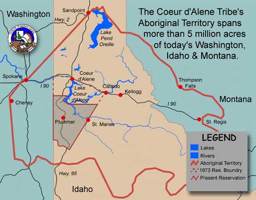
The aboriginal landscape of the Schitsu’umsh encompassed much of what would become the Panhandle region of Idaho, as well as parts of eastern Washington and western Montana (see the map). The northern boundary was marked by the lower end of Lake Pend Oreille, with the country to the north the home of the Kalispel and Pend Oreille peoples. The easterly area of Schitsu’umsh country extended into the Bitterroot Range of Montana. These are mountains with passes ranging from 4,700 to 5,200 feet in elevation, and the tallest peaks towering from 6,000 to almost 8,000 feet above sea level. On the other side of these mountains the Flathead people made their homes. The southern boundary followed the prairie region south of the Palouse River over to the North Fork of the Clearwater River and the Clearwater Mountains. Across these rivers and mountains was the country of the Nez Perce. The western reaches of the Schitsu’umsh landscape were set by "Plante’s Ferry," an early Indian crossing on the Spokane River just east of Spokane Falls, and then extended south along the Hangman (Latah) and Pine Creek drainages to Steptoe Butte. To the northwest and west was the home of the Spokane people, while to the southwest lived the Palouse Indians. In all it was a landscape that comprised over 4,000,000 acres of fir, ponderosa and cedar-forested mountains, freshwater rivers, lakes and marshlands, and white pine and perennial bunchgrass and fescue wheatgrass-covered rolling hills and prairie.
While these boundaries were recognized by both traditional neighbors and the Schitsu’umsh themselves, they were fluid delineations rather than confining barriers. Before settlement to their reservation in the late nineteenth century, Schitsu’umsh families seasonally traveled well into the Big Bend country far to the west of Hangman Creek to dig bitterroot, met with other Salish peoples at Kettle Falls on the Columbia to the northwest to fish and trade, gathered huckleberries with the Kalispel in the berry patches around Lake Pend Oreille to the north, or, after the arrival of the horse and accompanied by Spokane and Flathead families, traveled east into what would become Montana to hunt buffalo. And even today, some families continue to pick huckleberries in late summer in the mountains enveloping Lake Pend Oreille or to assemble at Spokane Falls with other regional tribes to share in song and dance, and renew kinship.
It is at the core of this vast landscape that the Schitsu’umsh consider their "home," "since time immemorial." This is the landscape that includes Coeur d’Alene, Hayden, and Liberty Lakes, the mouth of the Spokane River, and the entirety of the Coeur d’Alene and St. Joe River basins. And at the very heart is Lake Coeur d’Alene. The lake is some 23 miles long and has over 103 miles of lakeshore. Fed by numerous creeks and rivers, the largest of which are the St. Joe and Coeur d’Alene Rivers, the lake drains into the Spokane and eventually Columbia Rivers. Their own term for themselves, Schitsu’umsh, which literally translates "the ones that were found here," reiterates and affirms their identity as anchored in this specific landscape.