What this Reading Covers
What is Cover?
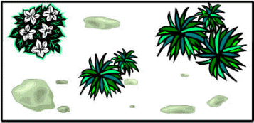
Cover is the area of the ground surface
covered by vegetation or other coverages including rocks, litter, moss, or bare
ground. Cover is expressed as a % of area. For example, if you look directly over
the quadrat below, you might estimate that the area
is covered by 35% Grass, 12%
White Flower, and 15%
rock. Then,
bare
ground (the area not
covered by vegetation or rocks) would be 38%.
|
 |
Grass:
 White
Flower:
Rock: |
Cover is assessed to describe which plants dominate the water and nutrient
resources on a site. Vegetative cover is also an important characteristic
that affects hydrological attributes of the site. Cover can be measured for the
entire vegetation in an area (e.g., "total vegetative cover was 45%"), or can be
applied to individual species (e.g., "sagebrush cover was 10 to 15%").
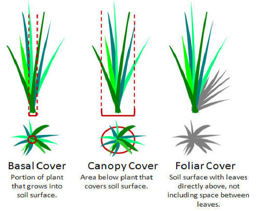
Four Types of Cover
Basal Cover = The proportion of the plant that extends
into the soil.
Compared to other estimates of cover, basal cover is:
- more stable from year to year and less sensitive to changes
due to climatic fluctuation.
- not affected by utilization by grazing animals.
- usually used for trend comparisons or for calculation of
species composition.
- can be difficult to measure for forbs or grasses with a single, small stem.
Canopy Cover = An estimate of the area of influence of the plant.
- Included influence of the roots below the leaf/stem canopy
- Ignores gaps in the canopy.
- Vertical projection of the outermost perimeter of the natural spread of
foliage of plants.
- For any area, the total canopy cover can exceed 100% because plants can
overlap.
Foliar Cover = A vertical projection of exposed leaf area. The
cover would equal the shadow cast if the sun was directly overhead.
- Small openings in the canopy or overlap within the plant are excluded.
- Highly susceptible to yearly fluctuations due to climatic or biotic
factors.
- Can be difficult to measure except for some growth forms. Easiest to measure
for forbs, shrubs or succulents with large leaves (i.e., cactus).
-
Leaf Area Index
is common way of measuring of foliar cover
Comparison of Basal, Canopy & Foliar Cover
Ground Cover = Cover of the soil surface with plants, litter,
biotic soil crust (i.e., mosses or lichens), rocks, or
gravel.
- Most often used to determine the watershed stability of the site.
Commonly included in measures of sparsely vegetated communities (i.e.,
deserts).
Three Approaches to Estimate Cover
Many different field methods have been invented to estimate basal, canopy,
foliar, or ground cover. However, all field methods are based on 3 basic approaches
that involve recording the occurrence of vegetative cover on
Points, Lines,
or Plots.
- Points = Examination of many points on a
site to estimate the proportion of "hits" or occurrences for a plants species or
type. (Covered in Lesson 8_3)
-
Lines
=
Assessment of the distance along a line that is intercepted by a plant species
or type. (Covered in Lesson 8_4)
-
Plots or Quadrats
= The proportion of area in a plot that is covered by a plant species or type.
(Covered in Lesson 8_5)
|