|
measuring cover
Basics for Point Measurements
A point is a very very small "plot" that is measured to determine
what plant or soil attribute occurs at that point. Assessment points are usually
accomplished with a "pin" or long metal wire that is sharpened to create a
"point." However, there are many variations on the point theme including, laser
points, and cross-hairs.
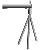 
Cross-Hair Sighting Device |
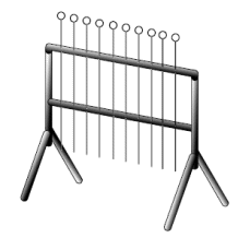
10-point Point Frame |
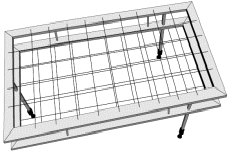
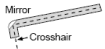
Cross-Hair Point Frame |
No matter how the point is created, the idea is the
same... at each point the species, vegetation type (i.e., grass, forb, or
shrub), or ground cover (i.e., rock, bare ground, biotic crust, etc.) that
intersects the
point is recorded as a "hit." The formula to calculate cover is simply the
proportion (%) of hits for a species of vegetation type:
For example, from
Measuring and
Monitoring Plant Populations (Elzinga et al. 1998; Fig 8.10, pg 182)
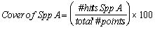
Ground, basal, canopy, and foliar cover can all be measured by point methods, depending on the rules established to guide decisions what
constitutes a hit. It is generally easier to determine if a point hit the base
of plant (i.e., basal cover) or a leaf (i.e., foliar cover) than if a point is in the canopy
of a plant. Therefore, points are seldom used to estimate canopy cover, though
it is possible.
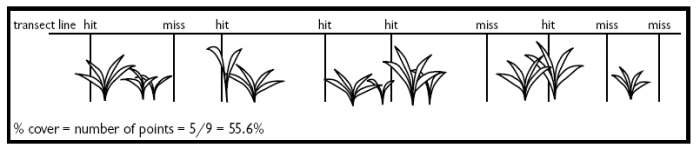
| For example, in this 10-point sample, what is the cover
of grass estimated as ground, basal, foliar, or canopy cover? |
 |
| Type of Cover |
1 |
2 |
3 |
4 |
5 |
6 |
7 |
8 |
9 |
10 |
% Cover |
| Ground |
No |
No |
No |
No |
No |
No |
No |
No |
No |
Yes |
10% grass (90% bare ground below leaves) |
| Basal |
No |
No |
No |
No |
No |
No |
No |
No |
No |
Yes |
10% grass |
| Foliar |
Yes |
Yes |
No |
Yes |
No |
No |
No |
No |
No |
Yes |
40% grass |
| Canopy |
Yes |
Yes |
No |
Yes |
No |
Yes |
Yes |
Yes |
No |
Yes |
70% grass |
Points to Estimate Ground Cover
Ground cover is most often and easily measured with a point technique. It is a quick
and objective way to assess how much plant cover is on a site or landscape.
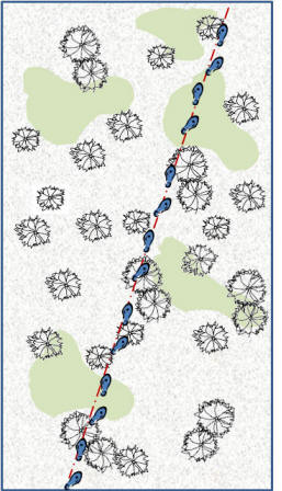
| One common technique used on grasslands and shrublands for
estimating ground cover is called the "Step-Point"
method. This involves selecting a point to
begin, setting a
transect direction with a compass bearing, then following the bearing
and recording what occurs at regular intervals along the transect.
 These
regular intervals are created by counting a number of paces between
"hits" which are usually a pin that is set to the ground at specific
"point" on the technicians boot. These
regular intervals are created by counting a number of paces between
"hits" which are usually a pin that is set to the ground at specific
"point" on the technicians boot.
For example, one might head off on a 120º
bearing across the landscape. At every step-point,
the field technician records a "hit" as a plant, biotic soil crust, or bare ground.
Data from 350 step-points might look like this:
|
 |
Layers of Vegetation - A Challenge and Opportunity
Measuring vegetation would be much easier (and more boring) if it occurred in
just one horizontal plane. But, this is seldom the case. The layers of
vegetation that occur in the real world create a problem and an opportunity when
conducting point measurements to estimate cover. There are basically two
solutions:
1) Ignore layers
- Make a rule to ignore anything except the top or bottom layer of
cover. Making a rule like this is okay as long as it meets your objectives, is
consistently followed, and stated in the results and methods. For example:
- When conducting a ground cover survey, the vegetation hanging over the
ground is ignored.
- When conducting a study of foliar cover or canopy cover only the top
layer of vegetation is usually be counted. Any vegetation below the top layer or
an the ground would be ignored.
2) Include Layers
- Record hits of vegetation encountered as the point is lowered. This
point-hit method is much more time consuming but gives a richer 3-dimensional
view of the site or landscape. For example, in the following four points, hits
would be recorded as such:
|
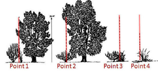 |
| Point |
Ground Level |
Veg Layer 1 |
Veg Layer 2 |
Veg Layer 3 |
|
| 1 |
Bare Ground |
Wheatgrass |
Bitterbrush |
Pinyon Pine |
|
| 2 |
Sagebrush |
Pinyon Pine |
|
|
|
| 3 |
Wheatgrass |
Rabbitbrush |
|
|
|
| 4 |
Litter |
Wheatgrass |
|
|
|
|
Data summary: Ground Cover =
25% bare ground, 50% perennial vegetation, and 25% litter
Vegetative Cover (of 8 hits): 38% wheatgrass (3 hits),
25% Pine (2 hits), 12 % Bitterbrush, 12% Sagebrush, 12%
Rabbitbrush. |
| Analysis of this multi-layer method can be
difficult. But, the field data would look like this:
----->
For more information about this method, read pages 73 through 77 of
Sampling Vegetation Attributes.
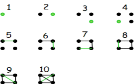
If you are not familiar with this Dot-Count Method it works
like this:
 |
 |
|
Points Can Be Combined with Other Methods
The use of points to estimate cover is so simple and flexible that it can be
used independently, as described above for the step-point method, or in
combination with other methods. For example:
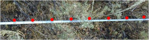
- Points Along a Line - Transects or
lines are used in many vegetation assessment protocols. Points are often
recorded at regular intervals along a transect that has been laid for other
techniques such as to estimate cover, frequency, structure, or biomass.
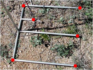
- Points on Plots - Once a quadrat is
place for biomass or frequency assessments, it is easy to examine what is
directly below each corner or point on the plot perimeter.
|