|
measuring cover
Basics for Line Measurements
A common and objective way to assess cover is by laying down a transect and
tallying up how much of a plant intersects the transect. This is called
the Line Intercept Method first described by Canfield in 1941.
(Canfield, R.H. 1941. Application of the line interception method
in sampling range vegetation. J. Forestry 39:388-394.)

A full description of how to conduct a line intercept in the field is
written in the
Sampling Vegetation Handbook

- The line intercept method is fairly objective. All the observer
must decide is what the plant species is and where the edge begins and ends.
- The beginning and end point for each time a plant intercepts the line
can be recorded and the total distance of intercept can be calculated back
in the lab.
- If sampling objectives can be met without keeping track of the exact
place where a plant intercepted the line, then all that needs to be recorded
is the distance of intercept along the line.
- Lines should be as thin as possible − in
theory, a line has no width at all. When reading distances along a transect
created with a measuring tape, read only along one edge of the tape. It is
also important to ensure that the tape is not inadvertently moved to
include or exclude certain plants.
- Usually lines are used to estimate basal and canopy cover, but can be
used for foliar cover for species that have large leaves and dense canopies.
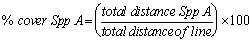
Cover is calculated as:
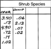
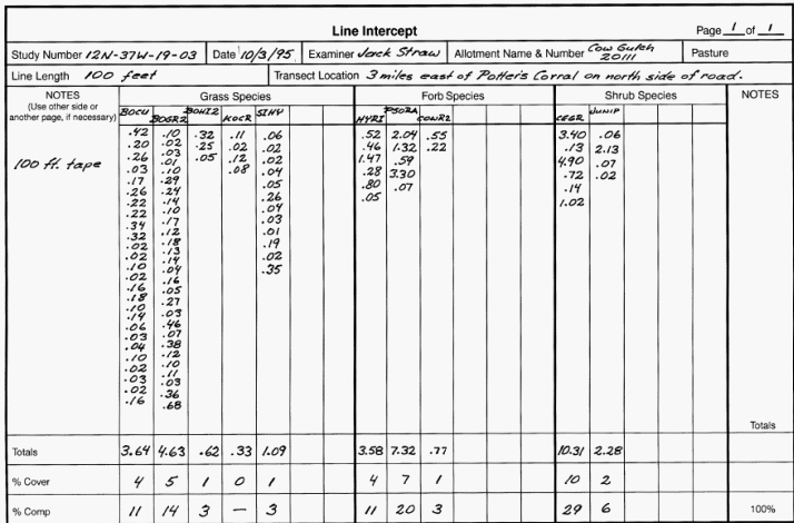
Data Example
Below is an example of Line Intercept data presented in the
Sampling Vegetation
Handbook.
- Notice that 4-letter codes are used for
species (like BOCU, or BOGR2). The species that the codes represent can be found in the USDA
Plants Database (www.plants.usda.gov).
- Notice that distances are measured and recorded in 10ths of
feet. This may seem a bit odd because there are 12 inches in a foot. It
therefore, takes a special transect tape measure to do this
− one that divides feet into 10 segments. But,
it makes sense for calculating distances. As in this example, when distances
(recorded in 10ths of feet) are totaled for a 100 foot tape, the
total distance = % cover.
- It turns out that a 100 foot (or 30 meter) distance is often used in
grassland and shrubland studies. This distance is about right
− generally long enough to get a good
representative sample, but short enough that several lines per site,
pasture, or landscape can be read.
Issues of Overlap and Gaps
The line intercept method is simple, just measure the distance of first
contact to the last contact of the species along the line. But, what
should be done when plants overlap on the line? And what if there is a gap in
intercept for a single plant?
A few rules to deal with issues of overlap and gaps in the field:
- Ignore overlap of individuals of same species.
- Disregard overlap of differing species. In other words, count the total
distance of a species regardless if it overlaps with another species.
- It may be difficult to tell where the canopy starts or ends. Create a
set of rules to use in the field to clearly describe how you determined
canopy dimensions.
- Decide what to do with a broken canopy within a shrub or tree. For
example, if there is a gap less than 2 inches you could ignore it but count
gaps greater than 2 inches. In other words, don't count the distance of the
gap (if > 2 inches) in total distance of intercept by the plant you are
measuring.
Summary
In the line intercept method, the line is the experimental unit. Therefore,
determine % cover for each line then average lines together to estimate cover
for the total landscape, site, or pasture.
Remember that because each plant species is examined separately and overlap
between species is allowed, the total cover along a transect determined by
distances of vegetation cover can exceed 100%.
It might seem intuitive that to get total cover for plant type (i.e., grasses,
forbs, shrubs, or trees) along a transect you could simply add the cover for all
plants of each plant type on a line to get the total % cover of by type. For
example, you could add all distances covered by a grass to get total grass
cover. But, this is not appropriate. Think about how overlapping
vegetation is handled along the line. If there was a lot of overlap between
species of the same plant type, then the total cover by plant type would be
inflated.
- It is possible to use the line intercept method to ascertain the total
cover by grasses, forbs, shrubs, or trees, but these distances must be
determined in the field.
- If the beginning end ending point of vegetation intercept is recorded
for each species, it would be possible to look at data back in the lab and
determine the total distance of intercept by plant type. It would be a bit
tedious, but measures of overlap between different species within a plant
type could be determined and removed from the total distance calculation.
|