GIS Tips
Home
Lab Info
Education
GPS
GIS Tips
Image Gallery
Links

  Installing
ArcGIS

Installing
ERDAS

How To work with spatial data in the Geospatial Learning Center                                 

bulletGIS Software
bulletTypes of GIS data - covarages, shapefiles and grids - how to view, copy and display shapefiles and coverages
bulletSources of spatial data
bulletHow to import spatial data to your GIS – zip -gz – Z -tar -e00 - stds - dem
bulletHow to examine a coverage in ArcView or ArcInfo
bulletProject a shapefile or coverage
bulletHow to make a CD from your ArcView project


GIS Software

Two GIS software packages are available in the Geospatial Learning Center:

ArcView 3.3  (also ArcView 9.2 is installed)

ArcInfo 9.2

Both software packages are made by ESRI (http://www.esri.com/).

The new version of ArcInfo has three new windows-based features, ArcCatalog, ArcMap and ArcToolbox. You can read more about the new features on the ESRI web-page or in the manuals available in the RS/GIS lab. You can run ArcInfo  with the command line by selecting ArcInfo Workstation under ArcInfo in the Start menu.


Types of GIS data

bulletArcView shape files

File structure: ArcView shape files have the extension .shp ArcView shape files always have two companions – the .dbf file and the .shx file. All three files MUST BE PRESENT for the shape file to function properly in ArcView. For example the shape file river.shp must be in the same directory as river.dbf and river.shx.


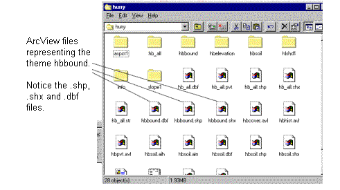
Copying: You can move shape files between directories on your computer by using ‘copy – paste’ in windows or ‘dragging and dropping’ files with the computer mouse. Always remember to also copy the .dbf and the .shx file to the destination directory. This also applies to renaming shape files. If the shape file river.shp is renamed to river2.shp the corresponding .dbf and .shx files MUST also be renamed river2.dbf and river2.shx.

Beyond .shx, .shp and .dbf files there are a sometimes other file extensions in ArcView such as .sbn, .sbx, .aih, and .ain. If you notice these files in your directory, for example river.sbn and river.sbx they MUST also stay together with the river.shp file. ALWAYS KEEP ArcView FILES WITH THE SAME PREFIX TOGETHER.

You can also use the Manage Data Sources in ArcView to copy, rename and delete ArcView shapefiles. Select File – Manage Data Sources in the main menu to activate this feature.

Shape files may display points, lines or polygons.

Display: ArcView shape files can be opened as themes in ArcView but can not be displayed in ArcInfo. A shape file can be converted to an ArcInfo coverage using the Arc command shapearc. An ArcInfo coverage can be converted to a shape file using the command arcshape in Arc.

View attributes: The attributes to a shape file are contained in the .dbf file. This file can be viewed in ArcView by making the theme active and pressing the Open table icon.


bulletArcInfo coverages

File structure: ArcInfo coverages appear as folders on the computer. If you open up the folder by double clicking you will see many files with names such as arc.adf, arx.adf, pal.adf, pat.adf etc.. The files inside the coverage folder are binary files and can not be viewed in and word processing program or ASCII editor. A folder that contains ArcInfo coverages is called a workspace. A workspace always contain a folder named info. The info folder contains attributes to all ArcInfo coverages within the workspace.

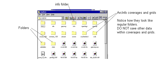
A folder that contains coverages is called a workspace.

Copying: You must use the command copy in ArcInfo when you copy ArcInfo coverages from one workspace to another. For example – copy the coverage river from c:\temp to e:

Enter the copy command at the Arc prompt:

Arc: copy c:\temp\river e:\river

The coverage river is now copied from the temp directory on the c drive to the e drive.

ArcInfo coverages CAN NOT be copied in the windows environment by ‘copy-paste’ or ‘drag and drop’ from one folder to the other. By copying in windows the data in the info directory will be lost and the coverage will be irrecoverably corrupted and lost forever. You may however move the entire workspace using the windows ‘copy-paste’ or ‘drag and drop’. For example the workspace idaho contains the coverages river and landuse. In the workspace idaho there is also an info folder. The entire workspace (folder) idaho may be moved with ‘copy – paste’ or ‘drag and drop’. However the individual coverages river and landuse must be copied using the Arc copy commad.

Display: ArcInfo coverages can be displayed in ArcInfo as well as in ArcView. You can also perform queries on ArcInfo coverages in ArcView, however you must save the coverages as a shape file before you can edit the polygons or attribute table.

Delete: Delete ArcInfo coverages with the kill command. For example, delete the coverage mycover:

Arc: kill mycover all This deletes the coverage mycover and all associated Info files.

List: List all ArcInfo coverages in a workspace

Arc: lc

Change workspace: Go to the workspace c:\temp

Arc: w c:\temp


bulletGrids

Grids are raster data with a specified pixel size.

In order to view grids in ArcView the Spatial Analyst extension must be turned on. When you add a grid theme the Data Source Type must be set to Grid.


In order to view a grid named testgrid in ArcInfo Workstation, use the following series of commands:

        Arc: grid (takes you into the grid module)

        Grid: display 9999 (activates the display screen)

        Grid: mape testgrid (sets map extent)

        Grid: gridshades testgrid (displays testgrid with the default shadeset)


Sources of spatial data

bulletThe Internet. Many links to useful data sources can be found at under the Links tab on the home page. The web page http://www.wildlife.uidaho.edu/ also has good links for GIS data.
bulletThe GIS library on our server Clan
bulletThe anonymous ftp site ftp.uidaho.edu //pub/gis/
bulletFederal and state agencies
bulletCounty and city offices
bulletPrivate companies


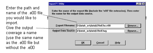
How to import spatial data to your GIS

Whether your spatial data comes from a web site, is transported via an ftp site or found in the lab spatial data library it will most likely come in one of the archive formats described below. Before you can view the data it must be converted to a shape file, coverage, grid, image or tin.

bullet.zip

Windows zip format. Use Winzip or Pkware to extract the files from the .zip file. The .zip file will in most cases self-extract if you double-click on the .zip file.

bullet.gz

Files with the exension .gz or .tar.gz are compressed and can be uncompressed with Window Winzip or Pkware.

bullet.Z

A Unix compressed file. Use the uncompress command on a Unix workstation to uncompress this file.

Example: Uncompress the file rivers.tar.Z

At the Unix prompt type : uncompress rivers.tar.Z

bullet.tar

A Unix archive format. The .tar file usually contains many files. To un-tar the file rivers.tar, use the following command at the Unix prompt: tar –xvf rivers.tar

bullet.e00

This is an ArcInfo export file. Coverages are often transported as .e00 files for easy transfer between folders on the workstation. Coverages that are not in export format must be copied using the copy command in ArcInfo.

Import in ArcView

From the Start menu select: Programs – ArcView – Import71 (don’t start ArcView!!)

Browse for the input .e00 file and name the output coverage in the following screen:

Import in ArcInfo

In order to import the file rivers.e00, type the following command at the Arc prompt:

Arc: import cover rivers.e00 rivers

(import, file type, input file, output coverage)

This imports the file rivers.e00 and names the output coverage rivers. To import a grid, replace the keyword cover with grid (import grid rivers.e00 rivers)


bullet.dem

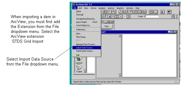
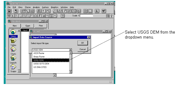
A .dem file is an ASCII file containing information to create an elevation grid (lattice) You can import the dem in ArcView or ArcInfo.


Select the .dem file with the browser and click OK.

Select a destination folder and a name for the output grid and click OK. ArcView will import the grid.


Import DEM in ArcInfo

Example: Import the dem named deary.dem to a lattice (elevation grid). Name the output grid deary_ele.

Arc: demlattice deary.dem deary_ele


bullet.stds


How to examine a coverage in ArcView or ArcInfo

We have just acquired the polygon coverage landuse and would like to examine the data.

ArcView

  1. Open ArcView with a new View.
  2. Set the View – Properties of your new View.
  3. Add the coverage landuse by selecting Add Theme from the View drop-down menu (or click the ‘Add Theme’ GUI). Then navigate to the folder where landuse is stored. Put a check-mark in the box in front of the theme name in the theme-table to view the added theme.
Note! When adding a grid or an image to the View, you must first add the Spatial Analyst Extension. When you select the theme change the Data Source Type to Grid or Image data source.


Note! ArcView may not recognize images, grids or coverages if there are spaces in the directory path, for example the following path may cause problems in ArcView:

C:\coverages\Geo 475\vector\

The space in the folder name Geo 475 may cause problems. Change the folder name Geo 475 to Geo_475 or something similar.


4.   Examine the attribute table of the coverage landuse selecting Table from the Theme drop-down menu or click the ‘Open Table’ GUI.


ArcInfo

1 . Arc: describe landuse

The describe command gives information about:
bulletThe number of arcs, points or polygons in the coverage
bulletThe bounding coordinates of the coverage
bulletWheather or not the coverage needs to be built in ArcInfo
bulletProjection – all coverages have a projection however sometimes it is not defined.

2. Arc: items landuse.pat

Display the attributes associated with the coverage. items also gives information about the length and type of each attribute – numeric items vs. string items etc.

3. Arc: list landuse.pat

Lists the attribute data of the coverage. Coverages has .pat and .aat files (polygon attribute table and arc attribute table). Grids have .vat fies (value attribute tables)

4. Draw the coverage in Arcplot or Grid

        Arc: grid (or arcplot)                                                                             starts the Gird or Arcplot session

        Grid: display 9999                                                                                   activates the display window

        Grid: mape landuse                                                                                 mapextent

        Grid: polys landuse                                                                                draw polygons

5. Arc: lc                                                                                                            list all the vector coverages in the workspace

6. Arc: lg                                                                                                            list all grids in the workspace


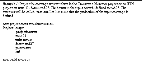
How to project a shapefile or coverage

In order to display the 3-dimensional surface of the earth on a flat 2-dimensional map the surface must be projected. There are many projections in different coordinate systems. The following three projections are commonly used in Idaho:

Idaho Transverse Mercator (ITM)is the standard projection for Idaho state data. Projection parameters as follows:

Projection:                     TRANSVERSE

Datum                             NAD27

Units:                              meters

Parameters

Scale factor at central meridian:     0.9996

Longitude of central meridian        -114 0 0

Latitude of origin                              42 0 0

False easting                                      500000.0

False northing                                    100000.0

Universal Tansverse Mercator (UTM) is the standard projection for many government agencies. Parameters as follows:

Projection:                           UTM

Datum:                                 NAD83

Units:                                   meters

Zone:                                   11

Parameters


The zone number varies within the US. Most of Idaho is in zone 11, however the eastern part of Idaho is in zone 12. Make sure you project your coverage in the correct zone.


Stateplane projection is commonly used in engineering and land planning applications, by the Army Corps of Engineers, county planners and engineering firms. Parameters as follows:

Projection:                         Stateplane

Datum                                NAD83

Units:                                 feet

Zone:                                 3751

Parameters

The zone number varies within the US and within each state. Idaho has three Stateplane zones, Idaho west (3751), Idaho east (3701) and Idaho central (3726). Latah county is located in the Idaho west zone.


Much of the data in /clan/library is in UTM, zone 11, datum nad27.

Shapefiles or coverages that are in different projections will NOT overlay when displayed in ArcView or ArcInfo! The shapefile or coverages must be projected in the SAME PROJECTION in order to overlay in a map composition.


Project shape files in ArcView 3.2

1. Turn on the Projector extension                                             File – Extensions – select Projector!


2. Open a view and add the theme you would like to project.                     View – Add theme

3. Set the View properties View-Properties

The units of your coverage or shapefile depend on what projection the file is in:

Geographic decimal degrees or degrees, minutes, seconds
UTM meters
Idaho Transverse Mercator meters
Albers or Lambert meters
Stateplane feet


4. Make the theme you want to project the active theme.

5. Press the Projector GUI and follow the instructions. Sometimes the input projection will be read from the input shapefile  and sometimes you will have to enter the input projection manually. Read the Projector instructions carefully.

 Note! Grids can not be projected in ArcView.


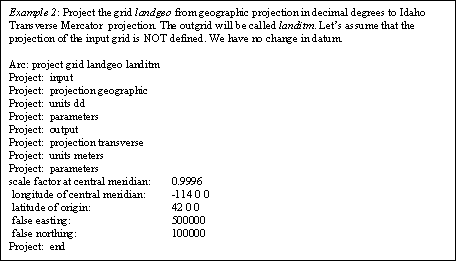
Project coverages and grids in ArcInfo

Coverages and grids can be projected in ArcInfo. The syntax is:

Arc: project <coverage/grid> <incover> <outcover>

The project module will then prompt you to enter a series of projection parameters.


How to make a CD from your ArcView project

What is an ArcView project?

An ArcView project has the extension .apr and is simply and ASCII text file. The project itself does not contain any of the shapefiles, coverages or grids that can be viewed when you open the project in ArcView. The ArcView project contains a series of lines pointing at shapefiles, coverages and grids in various folders on the computer you are presently working on. This is an example of part of an ArcView project:

          NOTICE the reference to the g: drive on the first line of the .apr file below!


Prepare a computer folder and ArcView project for a CD application

  1. Make a new folder. Let’s name the folder gis_data and place it on the C: drive of the computer in this example. This is the folder that eventually will be written to the CD.
  2. Copy all shapefiles, coverages, grids, images etc that you wish to include in your ArcView project on the CD into the new folder. The files may be placed in sub-folders within the folder gis_data. Make sure the size of the gis_data directory does not exceed approximately 580 Mbytes.
  3. Start ArcView and create Views, Layouts, Graphs etc. using ONLY data within the folder gis_data.

    If you plan to open the project on the CD on a laptop or other computer with a small monitor – make sure all your view-windows are small enough in size to fit the small monitor.

  4. Save the project in the folder gis_data. Let’s name the project studyarea.apr.
  5. Open the project studyarea.apr file with Wordpad or other word-processing program. Do a 'find and replace' on c:/gis_data

            The 'Find and Replace' feature is located under the Edit dropdown menu in most wordprocessing software.


Find: C:/gis_data

Replace: /gis_data


You need to replace the drive C: from the path because you don’t know what drive the CD reader is going to be on the computer where the studyarea.apr will be read.

6.   Save studyarea.apr in Wordpad and exit. Do not open and save studyarea.apr in ArcView after the above find/replace since a save will add the drive C: to the paths in the project again.


Write the CD

  1. Place a new recordable CD in the CD writer. Workstation NASA07 is hosting the CD writer in the RS/GIS lab.
  2. Open the ‘Easy CD-writer’ from the Start menu on the workstation. Follow the instructions and select the c:/gis_data when asked what data to include on the CD.
  3. Wait while your CD is being created.

If all worked well you should be able to open your ArcView project and view the data on the CD on any computer that has ArcView installed.


Geospatial Learning Center
College of Natural Resources
6th and Line Street
University of Idaho
Moscow, Idaho, 83844-1142

Eva Strand
email: evas@uidaho.edu
Phone: (208) 885-5779
Lab phone: (208) 885-7408
Fax: (208) 885-6226